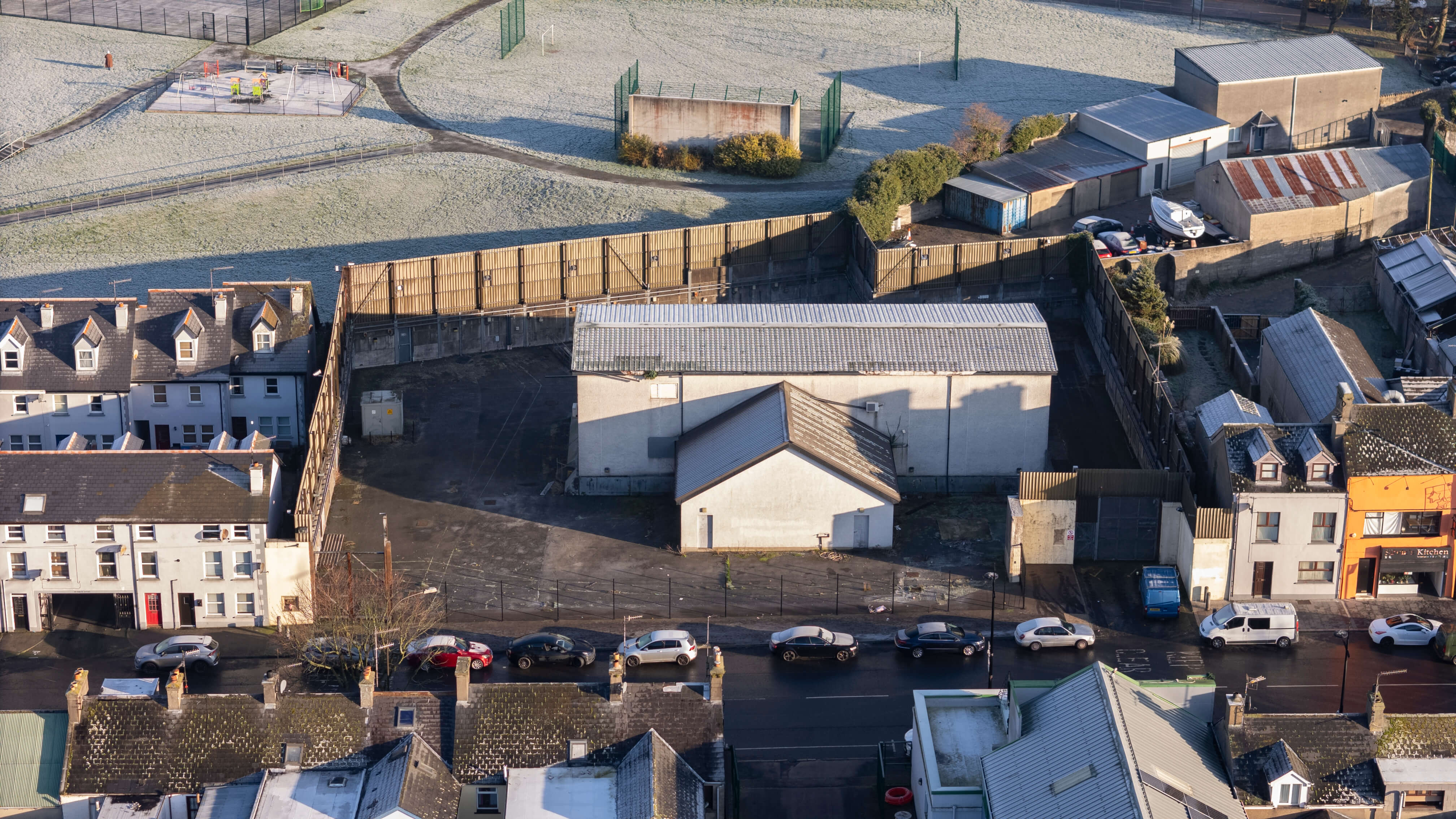
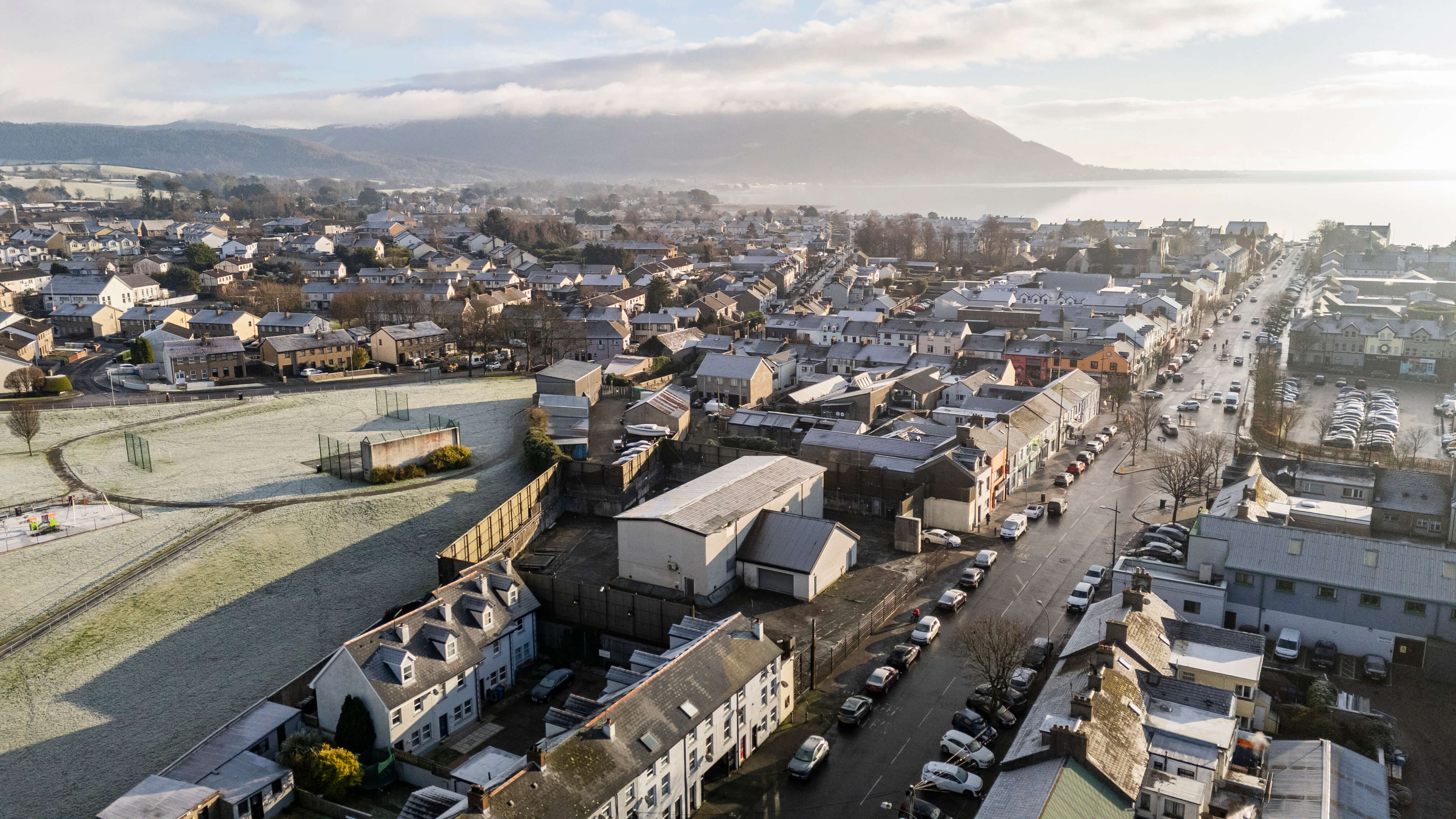
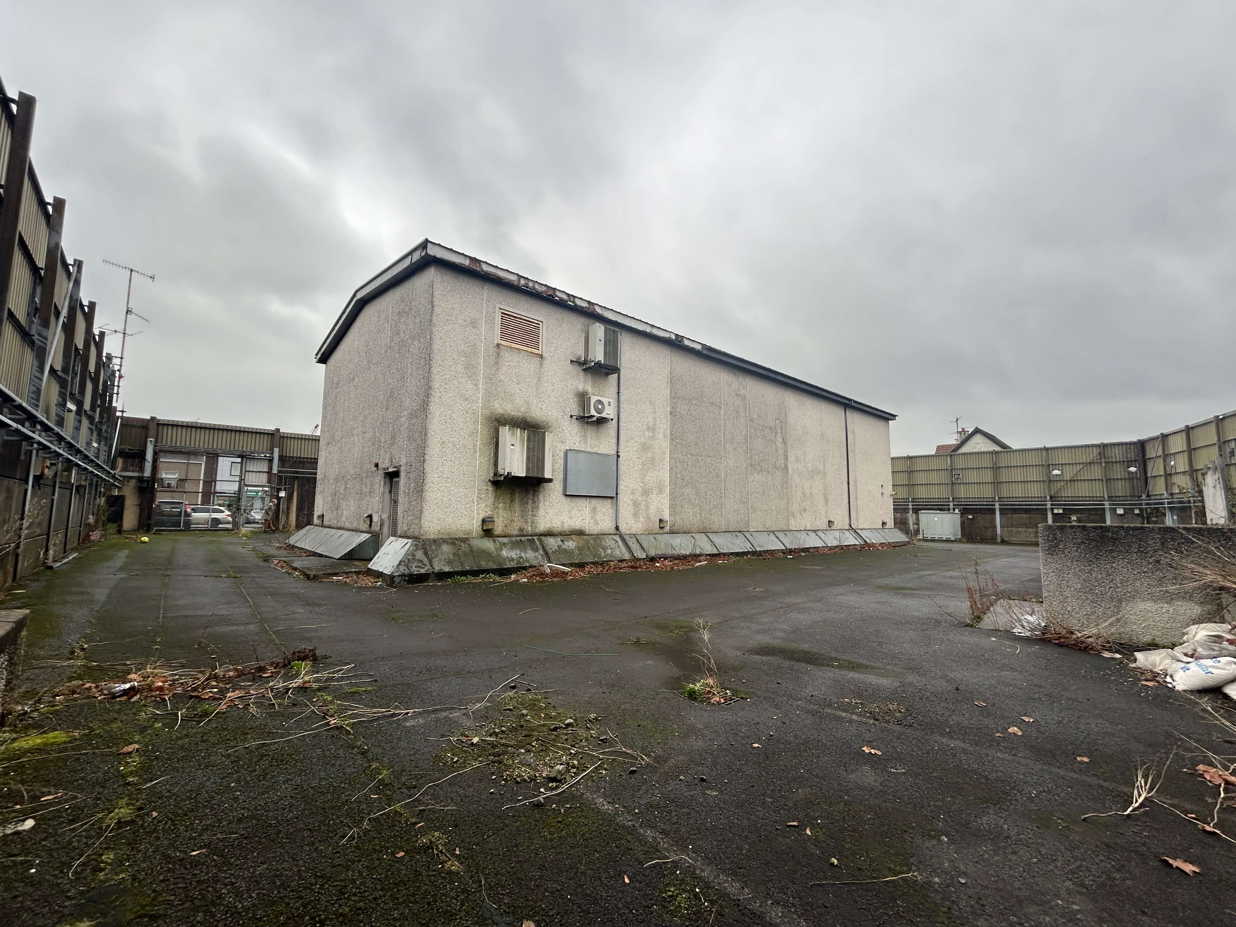
The former Warrenpoint Police Station closed to the public in 2014, then closed officially around 2018. The station sits on a flat, reasonably square shaped site of circa 0.6 acres in the town centre. The land is currently laid in tarmac and is well secured and bounded by walling and fencing. The former PSNI station sits in the centre of the land and comprises a large, two-story building. The building is circa 30 years old and was purpose built as a police station.
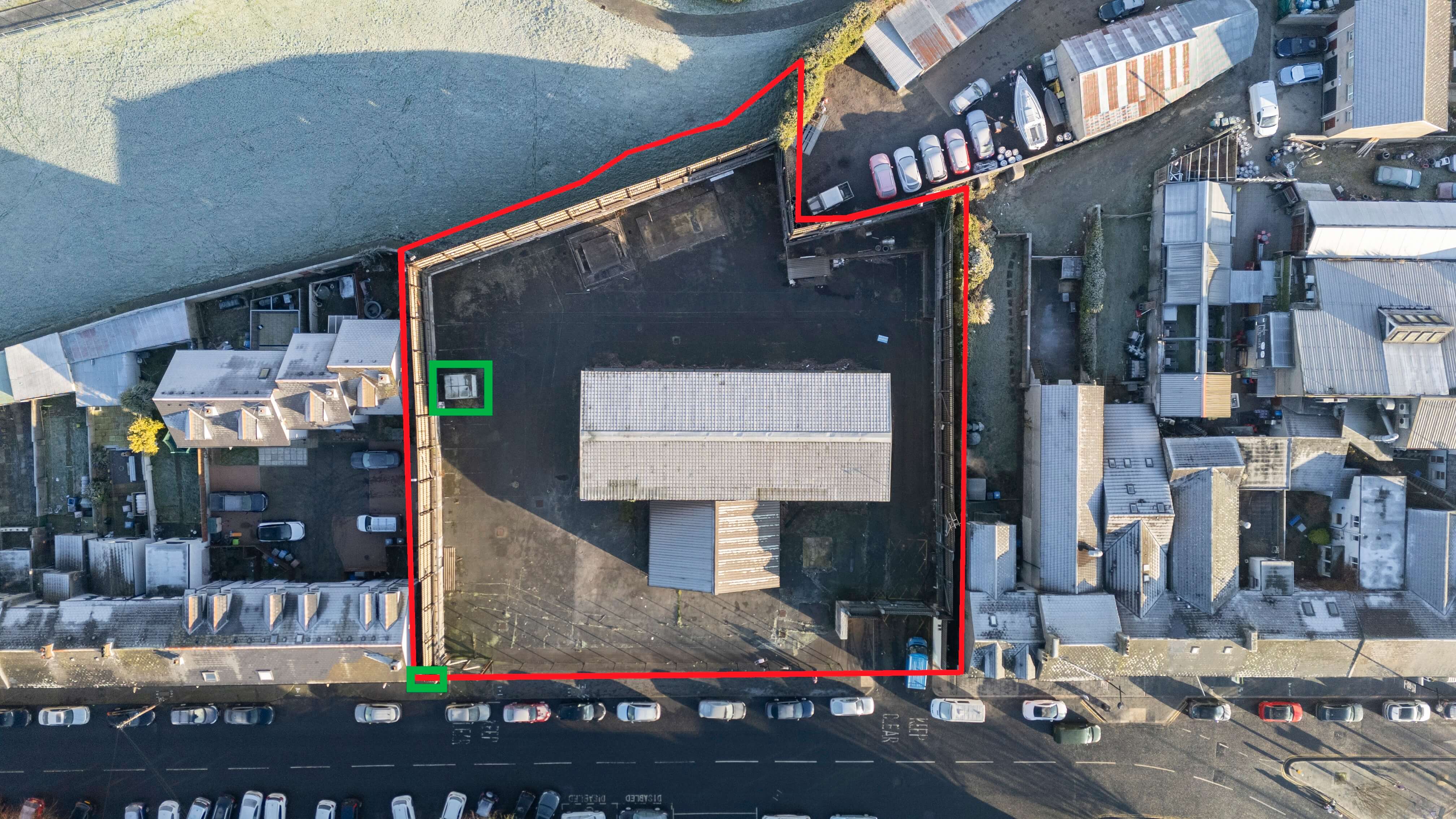
There is an NIE substation on the western boundary of the land, with a wayleave over the land to access this. We understand that the substation must remain and a Right of Way to access this is in place. We are also aware of a memorial plaque on the external southern boundary wall which must remain. Both the NIE substation and the memorial plaque are outlined in green in the aerial photo to the left
The former Warrenpoint Police Station closed to the public in 2014, then closed officially around 2018. The station sits on a flat, reasonably square shaped site of circa 0.6 acres in the town centre. The land is currently laid in tarmac and is well secured and bounded by walling and fencing. The former
The former Warrenpoint Police Station closed to the public in 2014, then closed officially around 2018. The station sits on a flat, reasonably square shaped site of circa 0.6 acres in the town centre. The land is currently laid in tarmac and is well secured and bounded by walling and fencing. The former PSNI station sits in the centre of the land and comprises a large, two-story building. The building is circa 30 years old and was purpose built as a police station.
There is an NIE substation on the western boundary of the land, with a wayleave over the land to access this. We understand that the substation must remain and a Right of Way to access this is in place. We are also aware of a memorial plaque on the external southern boundary wall which must remain. Both the NIE substation and the memorial plaque are outlined in green in the aerial photo to the left
Flat, square shaped land of c 0.6ac, well secured and bounded
Initial bids must be placed prior to12 NOON ON WEDNESDAY 26 MARCH 2025to ensure inclusion in the next round of bidding. We will only be accepting further bids after this date from parties who have already made an initial bid, providing all information below. After 12noon on the closing date, we will be doing a round-robin of phonecalls amongst the satisfactory bidders in order to bid this out.
A bidmustinclude the following;
Purchaser name and full contact details.
The proposed offer amount in pounds sterling.
Confirmation that your offer is not subject to any conditions
Proof of funds must be provided, by way of a bank statement or confirmation of funds letter from your bank, accountant or solicitor.
Purchaser ID – passport / driving licence & utility bill (dated within the last 2 months)
Your solicitor details.
Please note, the vendor reserves the right not to accept the highest, or indeed any, offer made.
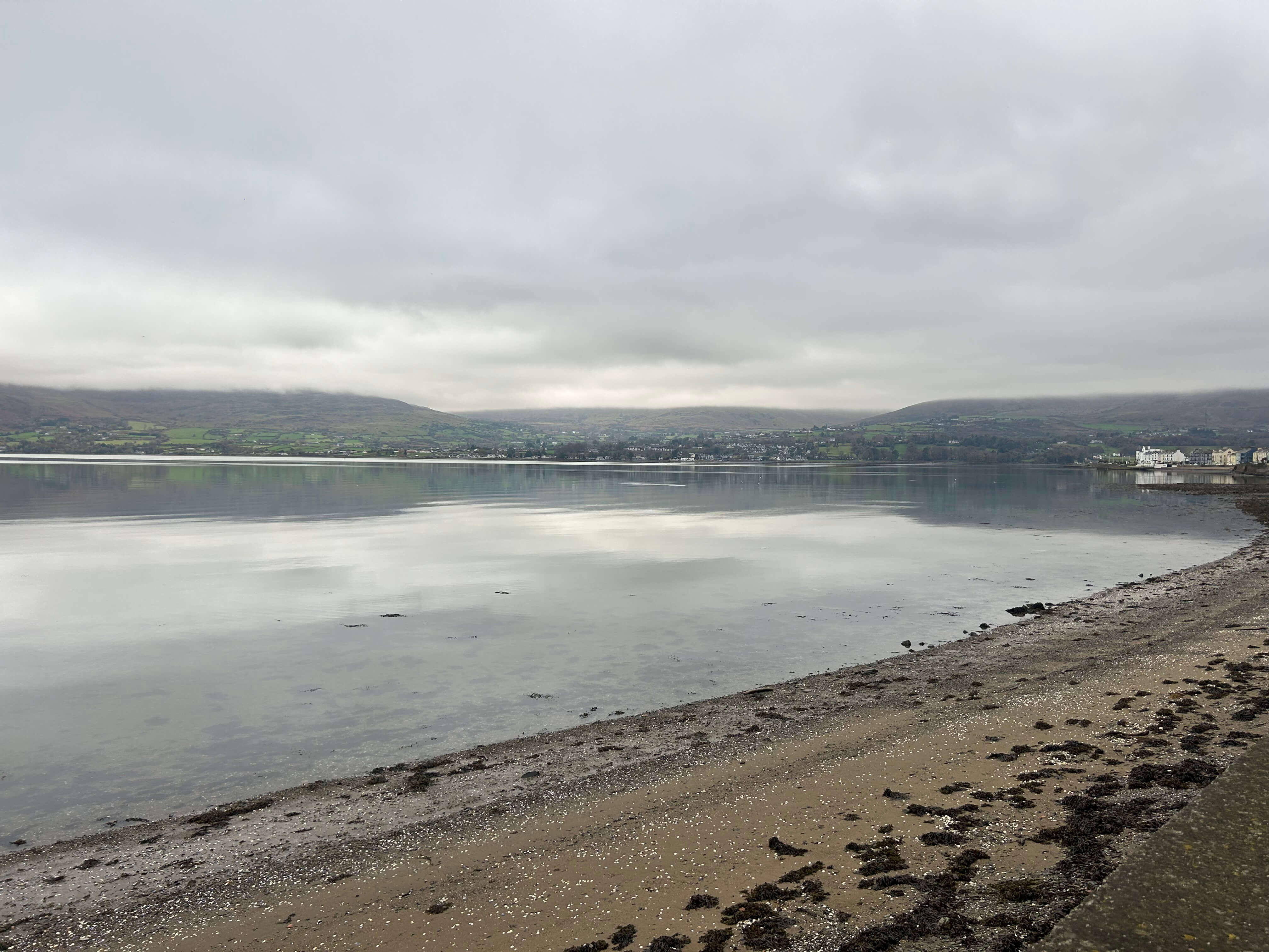
The subject property is located in Warrenpoint, a small coastal town located in County Down, situated between the Mourne Mountains to the northeast and Carlingford Lough to the east. Warrenpoint is situated approximately 8 miles east of Newry and around 50 miles south of Belfast, making it an important hub in the region. With a population of around 6,000 people, Warrenpoint is a predominantly residential town, attracting both locals and visitors drawn to its scenic views and proximity to outdoor activities in the Mournes. The Republic of Ireland sits just 500 meters southeast of Warrenpoint across Narrow Water. The Republic of Ireland is currently accessed by road, which is circa 11 miles, however the Narrow Water Bridge is currently under construction and following completion, will reduce the distance to around 1 mile.
Warrenpoint town Centre offers a range of local amenities which include shops, bars, restaurants and cafes. Community attractions include the town Centre, Mourne Golf Club, Warrenpoint Marina and the nearby Mourne mountains for leisure activities. St. Paul’s High School, Our Lady’s Grammar School and Warrenpoint Primary School are all within the town. Land uses surrounding the subject comprise as outlined below:
North: Recreation lands and residential areas
East: Charlotte Street and town centre
South: Charlotte Street and town centre
West: Retail and residential
Initial bids must be placed prior to 12 NOON ON WEDNESDAY 26 MARCH 2025 to ensure inclusion in the next round of bidding. We will only be accepting further bids after this date from parties who have already made an initial bid, providing all information below. After 12noon on the closing date, we will
Initial bids must be placed prior to12 NOON ON WEDNESDAY 26 MARCH 2025to ensure inclusion in the next round of bidding. We will only be accepting further bids after this date from parties who have already made an initial bid, providing all information below. After 12noon on the closing date, we will be doing a round-robin of phonecalls amongst the satisfactory bidders in order to bid this out.
A bidmustinclude the following;
Purchaser name and full contact details.
The proposed offer amount in pounds sterling.
Confirmation that your offer is not subject to any conditions
Proof of funds must be provided, by way of a bank statement or confirmation of funds letter from your bank, accountant or solicitor.
Purchaser ID – passport / driving licence & utility bill (dated within the last 2 months)
Your solicitor details.
Please note, the vendor reserves the right not to accept the highest, or indeed any, offer made.
The subject property is located in Warrenpoint, a small coastal town located in County Down, situated between the Mourne Mountains to the northeast and Carlingford Lough to the east. Warrenpoint is situated approximately 8 miles east of Newry and around 50 miles south of Belfast, making it an important hub in the region. With a population of around 6,000 people, Warrenpoint is a predominantly residential town, attracting both locals and visitors drawn to its scenic views and proximity to outdoor activities in the Mournes. The Republic of Ireland sits just 500 meters southeast of Warrenpoint across Narrow Water. The Republic of Ireland is currently accessed by road, which is circa 11 miles, however the Narrow Water Bridge is currently under construction and following completion, will reduce the distance to around 1 mile.
Warrenpoint town Centre offers a range of local amenities which include shops, bars, restaurants and cafes. Community attractions include the town Centre, Mourne Golf Club, Warrenpoint Marina and the nearby Mourne mountains for leisure activities. St. Paul’s High School, Our Lady’s Grammar School and Warrenpoint Primary School are all within the town. Land uses surrounding the subject comprise as outlined below:
North: Recreation lands and residential areas
East: Charlotte Street and town centre
South: Charlotte Street and town centre
West: Retail and residential
We note that there is no live planning on the land.
The subject land falls under two development maps within the Banbridge, Newry & Mourne Area Plan 2015.
Under both Maps, the subject land falls just outside the Warrenpoint Town Centre Limit but falls within an Area of Outstanding Natural Beauty and within an Area of Townscape Character.
All prices, outgoings and rentals are exclusive of, but may be liable to VAT.
Stamp duty will be the liability of the purchaser.
As a business carrying out estate agency work we are required to verify the identity of both the vendor and the purchaser as outlined in the following: The Money Laundering, Terrorist Financing and Transfer of Funds (Information on the Payer) Regulations 2017 – https://www.legislation.gov.uk/uksi/2017/692/contents. Any information and documentation provided by you will be held for a period of five years from when you cease to have a contractual relationship with Lisney. The information will be held in accordance with General Data Protection Regulation (GDPR) on our client file and will not be passed on to any other party, unless we are required to do so by law and regulation.
Lynn Taylor: 028 9050 1501 / 07813 020 181
ltaylor@lisney-belfast.com
Viewing strictly by appointment with the sole selling agent Lisney
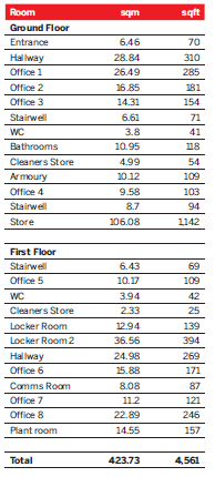
Accommodation
We understand from measurement taken off Spatial NI the site measures 0.6 ac.
Thanks for showing an interest in our research reports. For access to our archive, just add your details and we’ll get back right away with your account confirmation and the publications you’d like to read.
Thanks for showing an interest in our research reports. For access to our archive, just add your details and we’ll get back right away with your account confirmation and the publications you’d like to read.