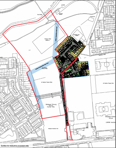
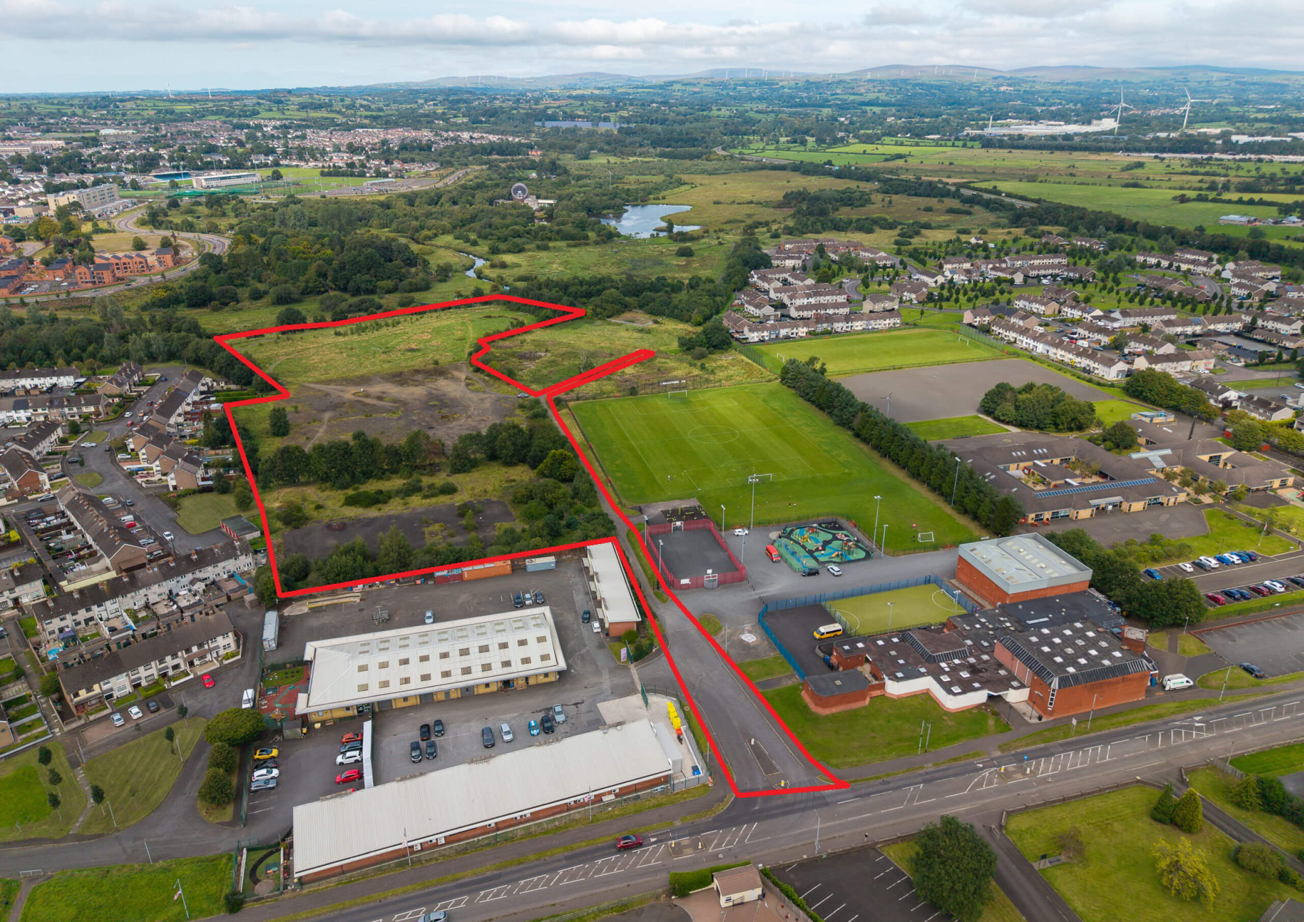
The subject land comprises a rare and attractive plot of potential residential development land in the heart of Ballymena (STPP).
Well-positioned approximately 0.6 miles from the town centre, and just minutes from key transport links, this site offers an exceptional canvas for a high-quality housing development or various other alternative uses (STPP).
The land benefits from relatively flat topography which slopes slightly downwards from south to north toward the Braid River.
The land is accessed via Ballykeel Lane off the Crebilly Road. The freehold to Ballykeel Lane is included within this sale and all Rights of Way for the surrounding landowners will be retained. Rights of Way include Ballykeel Business Park, Ballykeel Youth Club and the playing fields, the developer of the adjoining lands, NI Water and NIE.
Please see the Planning Section for further information on this.
The land is made up of three main areas:
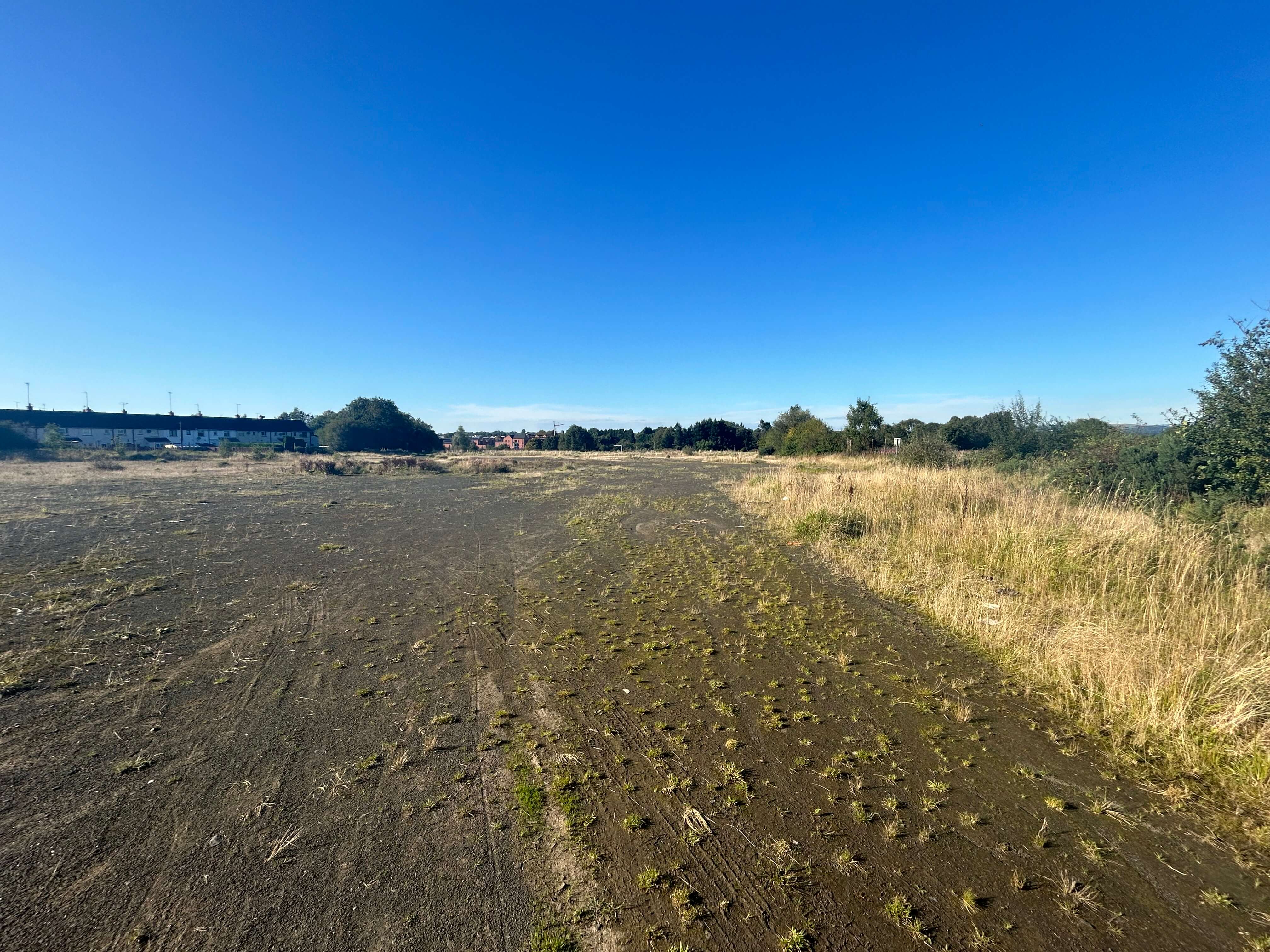
• The land which sits behind Ballykeel Business Park, is where the former Ballykeel Primary School once stood (now demolished). This part of land is bordered by trees and hedging with parts of the site paved in tarmac, part in hardcore.
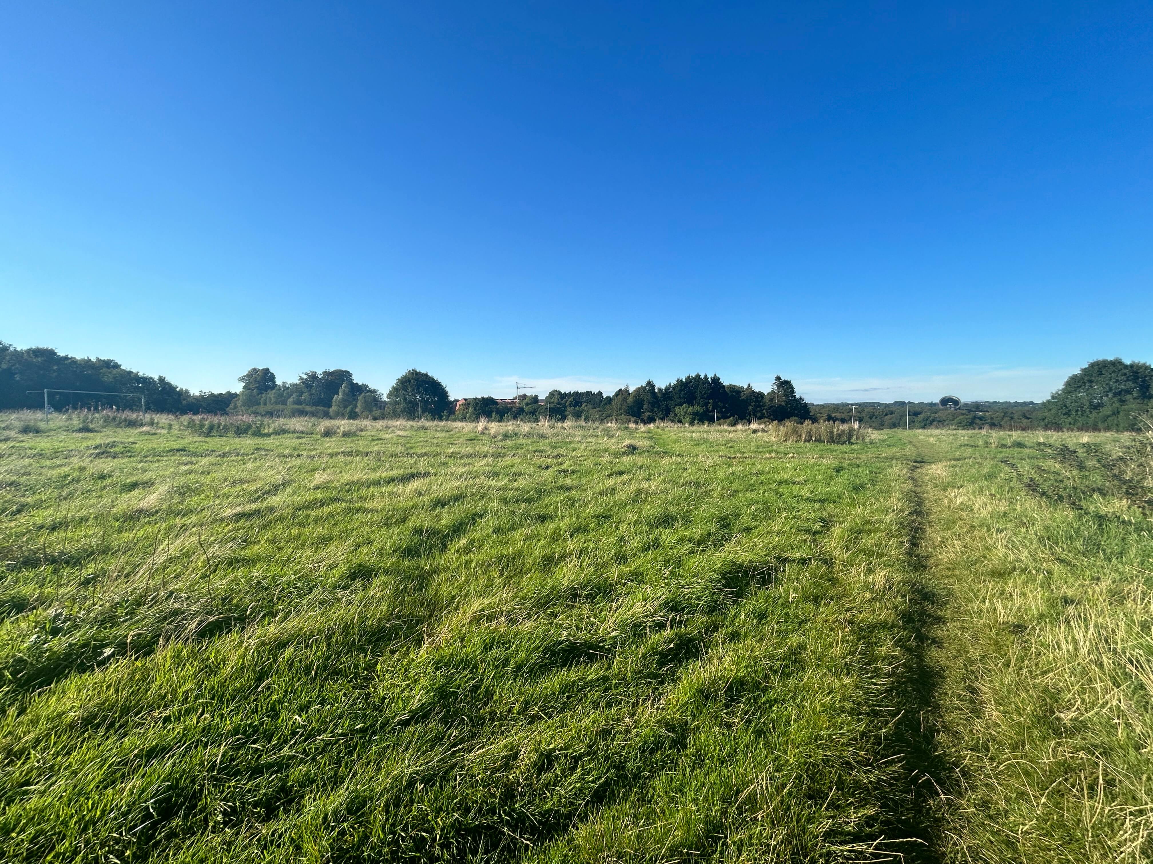
• The former hockey pitches in the centre of the lands. This land is expansive, flat and laid in gravel.
• Grassed areas at the northern end of the land which run down to the River Braid. A legal public path laid in tarmac runs through the northern piece of land.
We note that a small area of the riverbank in the subject lands is subject to floodplain designation.
The subject land comprises a rare and attractive plot of potential residential development land in the heart of Ballymena (STPP).
Well-positioned approximately 0.6 miles from the town centre, and just minutes from key transport links, this site offers an exceptional canvas for a high-quality housing
The subject land comprises a rare and attractive plot of potential residential development land in the heart of Ballymena (STPP).
Well-positioned approximately 0.6 miles from the town centre, and just minutes from key transport links, this site offers an exceptional canvas for a high-quality housing development or various other alternative uses (STPP).
The land benefits from relatively flat topography which slopes slightly downwards from south to north toward the Braid River.
The land is accessed via Ballykeel Lane off the Crebilly Road. The freehold to Ballykeel Lane is included within this sale and all Rights of Way for the surrounding landowners will be retained. Rights of Way include Ballykeel Business Park, Ballykeel Youth Club and the playing fields, the developer of the adjoining lands, NI Water and NIE.
Please see the Planning Section for further information on this.
The land is made up of three main areas:
• The land which sits behind Ballykeel Business Park, is where the former Ballykeel Primary School once stood (now demolished). This part of land is bordered by trees and hedging with parts of the site paved in tarmac, part in hardcore.
• The former hockey pitches in the centre of the lands. This land is expansive, flat and laid in gravel.
• Grassed areas at the northern end of the land which run down to the River Braid. A legal public path laid in tarmac runs through the northern piece of land.
We note that a small area of the riverbank in the subject lands is subject to floodplain designation.
Circa 12 acres of land with Potential for Residential Development (STPP)
Zoned white land within development limit
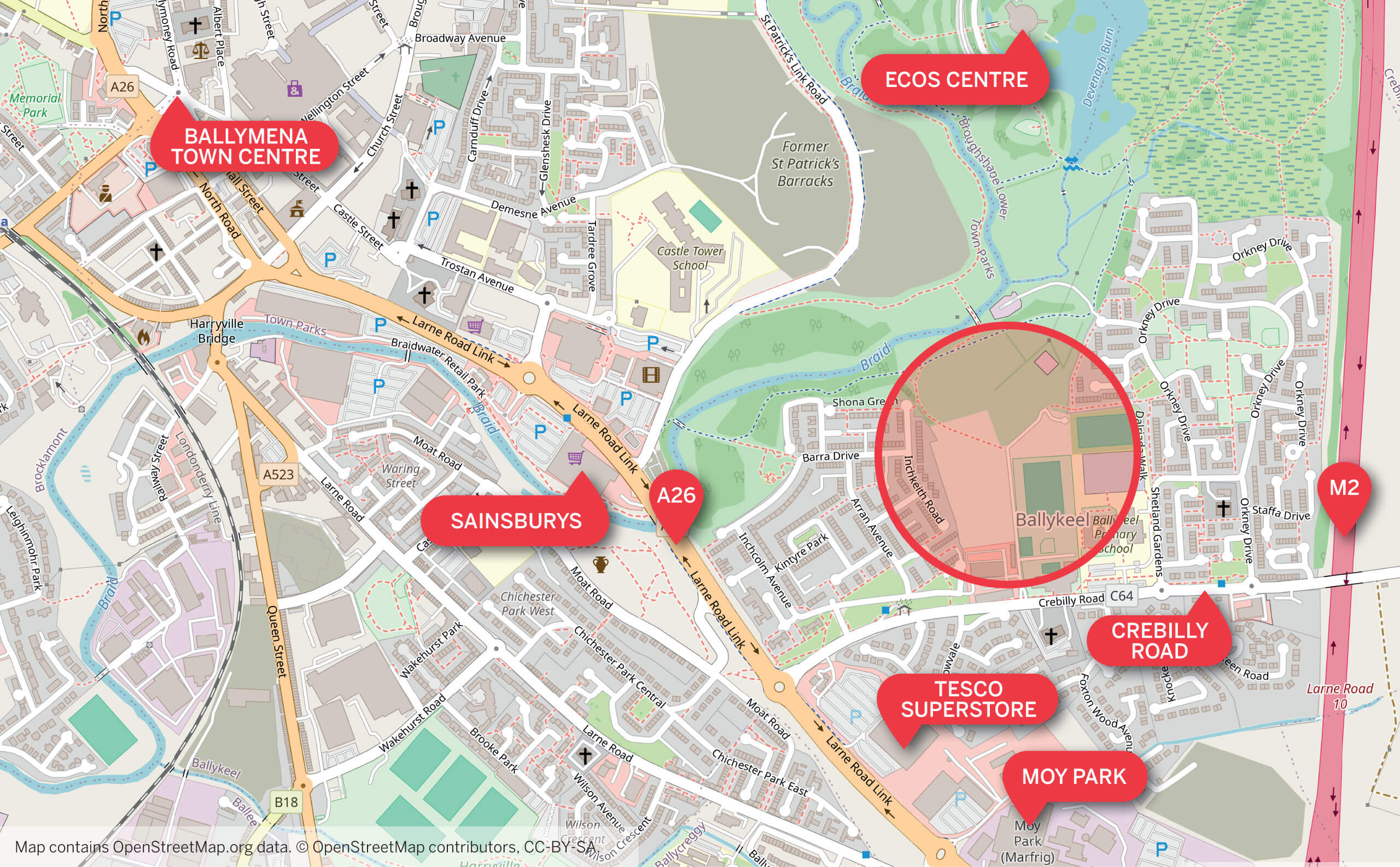
Just 0.8 miles to the M2 Motorway and 0.6 miles to Ballymena town centre
Located in a well-established market with strong demand for residential development
Adjacent to existing social housing developments, recreation lands and community facilities
The subject property is located in Ballymena, a town in County Antrim with a population of circa 31,000 people (2021 census), making it the seventh largest town in Northern Ireland by population.
The town is located approximately 28 miles from Belfast, 12 miles from Antrim and 22 miles from Larne. The subject lands are extremely well located on the Crebilly Road, just off the main A62 Larne Road Link which runs from the M2 into Ballymena Town Centre.
The M2 Motorway is just 0.8 miles from the land, providing exceptional transport connectivity and supporting excellent regional access.
The surrounding land uses include:
North: Braid River, a Radius Housing Association residential development on the former St. Patrick’s Barracks and The Ecos Centre.
East: Ballykeel Primary School, Playing Fields & Park and Orkney Drive, a social housing development.
South: Crebilly Road, Tesco Superstore, Ballykeel Youth Centre and Ballykeel Business Centre.
West: A26 Larne Road Link and Arran Avenue social housing development.
The subject property is located in Ballymena, a town in County Antrim with a population of circa 31,000 people (2021 census), making it the seventh largest town in Northern Ireland by population.
The town is located approximately 28 miles from Belfast, 12 miles from Antrim and 22 miles from Larne. The
The subject property is located in Ballymena, a town in County Antrim with a population of circa 31,000 people (2021 census), making it the seventh largest town in Northern Ireland by population.
The town is located approximately 28 miles from Belfast, 12 miles from Antrim and 22 miles from Larne. The subject lands are extremely well located on the Crebilly Road, just off the main A62 Larne Road Link which runs from the M2 into Ballymena Town Centre.
The M2 Motorway is just 0.8 miles from the land, providing exceptional transport connectivity and supporting excellent regional access.
The surrounding land uses include:
North: Braid River, a Radius Housing Association residential development on the former St. Patrick’s Barracks and The Ecos Centre.
East: Ballykeel Primary School, Playing Fields & Park and Orkney Drive, a social housing development.
South: Crebilly Road, Tesco Superstore, Ballykeel Youth Centre and Ballykeel Business Centre.
West: A26 Larne Road Link and Arran Avenue social housing development.
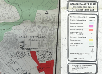
The land falls under the Ballymena Area Plan 1986–2001 and is within the Development Limit, zoned as White Land.
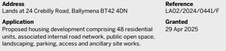
We note the land falls within an area with precedent residential planning approvals, with 48 dwellings granted full planning permission on adjoining lands and 140 dwellings recently completed in the former St Patrick’s Barracks, just on the other side of the River Braid.
A notable planning application relating to land adjoining ours, together with the overlaid plan, can be found below:
The access laneway (called Ballykeel Laneway) that connects this new development to the Crebilly Road is included in this sale and will fall under the purchaser’s ownership, however the developer of the adjoining land has a Right of Way which is registered on title over Ballykeel Laneway. By formal easement with the existing vendor and under this planning application, the developer of the adjoining land will undertake all necessary upgrading works to Ballykeel Laneway to bring it to the level required to allow for adoption by the Department for Infrastructure.
We note that services will be available for the subject lands from points on the upgraded Ballykeel Laneway.
The Grant of Easement document relating to Ballykeel Laneway/right of way/works etc, can be made available upon request.
Freehold
£1.8 million
We understand the sale is not subject to VAT.
Stamp duty will be the liability of the purchaser.
As a business carrying out estate agency work we are required to verify the identity of both the vendor and the purchaser as outlined in the following: The Money Laundering, Terrorist Financing and Transfer of Funds (Information on the Payer) Regulations 2017 – https://www.legislation.gov.uk/uksi/2017/692/contents. Any information and documentation provided by you will be held for a period of five years from when you cease to have a contractual relationship with Lisney. The information will be held in accordance with General Data Protection Regulation (GDPR) on our client file and will not be passed on to any other party, unless we are required to do so by law and regulation.
For further information:
George Jolliffe: 028 9050 1501 / 07718 493 197
gjolliffe@lisney-belfast.com
Viewing strictly by appointment with the sole selling agent Lisney
Accommodation
From measurement taken on Spatial NI, we estimate that the total land extends to circa 12 acres (4.86 hectares).
You may also like
‘Ready to Go' Residential Development Opportunity, 25-45 Dundela Avenue, Belfast, BT4 3BS
Thanks for showing an interest in our research reports. For access to our archive, just add your details and we’ll get back right away with your account confirmation and the publications you’d like to read.
Thanks for showing an interest in our research reports. For access to our archive, just add your details and we’ll get back right away with your account confirmation and the publications you’d like to read.